Posts

UAS Capstone Strategy Session

During Class time on November 20, my classmates and I engaged in a "Capstone Project Strategy Session". This session was used to discuss our progress in our capstone ideas as well as discuss the potential for combining into one group. Through careful discussion, the eight of us decided to come together to work on a project together. For this project, we will each take on a specified role to create GIS maps, 3D models, and other data sets that could be found useful for the Tippecanoe County Amphitheater Park.  The exact plan for what we are aiming to do is still under discussion. There is a wide range of terrain in this park: a parking lot, an amphitheater, soccer fields, and a riverbed. Hopefully we will be able to accomplish some data collection surrounding how rainfall affects the flooding of the park. We will be provided with a wide range of aircraft and sensors, so our team will develop specific flight missions in the next coming weeks. We have established individual ...
Geospatial Video

Image
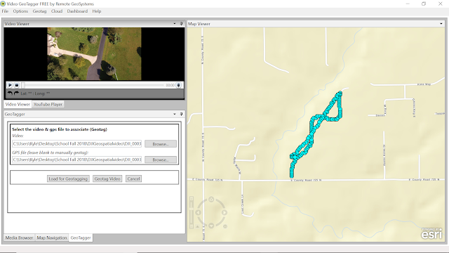
During this lab exercise, we worked with geospatial video to demonstrate how the location of a UAV can be tied to a map as well as the video that the aircraft is seeing at that time. Oftentimes in the UAS industry, we deal with nadir (straight down shots). These shots are then tied to GPS coordinates for mapping purposes. However, there are instances when we need shots obtained from a different angle so as to capture the surrounding areas gathering more information. While reviewing the captured video, either post flight or during flight, it is important to know where the UAV is and where it is looking. This information can be very beneficial for operations such as search and rescue, firefighting, surveillance, etc. Geospatial video allows us to see this data. The idea for the lab was simple: take the data we were given and turn it into the final product. The process however, was not as concrete. In previous labs, our instructor has either given us step-by step instructions or walked ...

Field Outing 11/08

Image
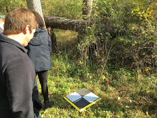
During lab on November 8th, we went out to Dr. Hupy's property to practice placing and optimizing ground control points. To begin the day, Dr. Hupy explained the layout of the property so we would have a good idea on where to place the ground control points. From there, we walked around the property marking elevation change, noting possible flight path obstructions, and placing down ground control points around the area to obtain sufficient and equal spacing between them. The GCPs we used were simple, as we could turn them on and place them down as they gathered their specific GPS data. One important thing to note about these GCPs is that they must be picked up in the reverse order which they were placed. So, with each point placed we were sure to note key characteristics of the surrounding environment. This was to help us find the points during post-processing and identify which ones were placed in order. One of the GCPs placed in the back woods, behind this was a creek tha...

Annotated Bibliography

For my capstone project, I have chosen to pursue creating an effective way for UAS to be used in accident reconstruction, either aviation or vehicular. I believe that UAS can be a very effective tool for gathering data at a crash site providing high accuracy and quick results. For this project, I conducted some introductory research which is outlined by the annotated bibliography below. The main goals of this research were A) if this had been done before, B) if so, what are some of the different ways of going about it, C) can off-the-shelf aircraft be used effectively? Another part of this was to create a research timeline. This will be important in maintaining proper scheduling of flights and research so that I do not fall behind. Indiana winters are extremely variable so I did not plan out specific dates for flights to be completed, however I provided general date ranges that can still be achieved. Ideally I will be able to run test flights in the early months of the winter, but ...

McCormick Park Field Outings

Image
Over the course of the previous two weeks, my classmates and I have engaged in aerial data collection over a forest located 1.7 miles from Purdue University Airport (KLAF). The flights were conducted in conjunction with local air traffic, and approval was received from KLAF for these flights. We went out to fly multiple days and flew various aircraft. There were instances where either: the flight path was not registered by the aircraft, the data was not captured during the mission, or the aircraft would lose signal mid-flight. This caused us to rotate between different aircraft. Since the flight was over a large wooded area, it was difficult for the flight crew to maintain visual line of sight (VLOS) during the operation. To solve this problem, we broke up into three different teams around the perimeter of the woods and maintained radio contact throughout the course of the operation. This "daisy-chain" allowed us to conduct an autonomous flight mission even though the pilot...

UAS Map Creation Lab 2

Introduction * What is GIS? That is, is it just software. What did Dr. Christina Hupy stress when she spoke about what defines what exactly constitutes GIS? A GIS, or geospatial information system is a system that captures geographical data in a certain area. The GIS is more than just the software used to create it, because you need data and a scale to reference the data to. GIS is more related to understanding all of the data as opposed to just the software. * What makes open source GIS (QGIS) different than proprietary (ESRI) GIS? And What are advantages and disadvantages between the two? Open source GIS is created and then developed by the community. People can take the source code and then edit it however they see fit. This is nice for customization options because people frequently release various code updates, however if you want support for said code it may be difficult to get because everything is rapidly changing. Proprietary GIS such as ESRI is developed by a sp...

ArcMap and ArcScene Map Creation

Created map located under 'Figures' Page... * Why are proper cartographic skills essential in working with UAS data? It is very important to be able to show your audience your UAS data in a clear and concise manner. Illustrating a map is a very effective way to do so. It shows your audience the important features of your data set, the direction reference with a compass rose, and even key flight data such as time, date, etc. * What are the fundamentals of turning either a drawing or an aerial image into a map? A drawing/illustration needs a few things to become a map: a scale, a legend, a coordinate system, watermark, and attribute data. If it is missing one or more of these components, then it is technically not a map. A scale and coordinate system give those viewing it some insight into the image they are looking at. A legend explains key features of the map, and attribute data is used to provide key flight information. The watermark is essential in making your dat...