UAS Map Creation Lab 2
Introduction
* What is GIS? That is, is it just software. What did Dr. Christina Hupy stress when she spoke about what defines what exactly constitutes GIS?
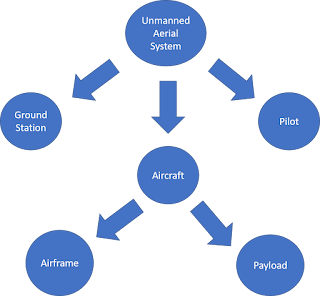
A GIS, or geospatial
information system is a system that captures geographical data in a certain
area. The GIS is more than just the software used to create it, because you
need data and a scale to reference the data to. GIS is more related to
understanding all of the data as opposed to just the software.
* What makes open source GIS
(QGIS) different than proprietary (ESRI) GIS? And What are advantages and
disadvantages between the two?
Open source GIS is created
and then developed by the community. People can take the source code and then
edit it however they see fit. This is nice for customization options because
people frequently release various code updates, however if you want support for
said code it may be difficult to get because everything is rapidly changing.
Proprietary GIS such as ESRI is developed by a specific group with
secure source code. If you want something different you are unable to edit it,
however you do receive support if you run in to any problems. * Why is Open Source GIS important to the UAS industry? That is, speculate upon your own experiences and goals to relate how this software could open doors and markets where proprietary GIS keeps doors closed.
Open
Source GIS allows new code to be developed very frequently, which is beneficial
in a rapidly changing UAS industry. As new UAS technologies become developed
some systems may not work as well with proprietary GIS because the GIS does not
change as rapidly as the UAS technology might. Also, open source GIS allows
mass groups of people to be involved in the creation and development of these
new software technologies whereas proprietary GIS is restrictive to its own
employees. If someone wants to get into GIS development, they are easily able
to work with open source software to develop their skills.
Method/Discussions
During our lab time, we
created a hillshade by using sample multicomposite data. This hillshade was
designed by first loading in the data to the GIS software. After the DEM was
loaded in we then adjusted the properties of said DEM to match the elevation
values to minimum and maximum elevation values to show greater contrast between
the changing elevation. Afterwards we generated a hillshade effect onto the DEM
and tinkered with settings until a good-looking image was developed. The
difference between this creation and the previous one was that we were shown
extra menu options and search keys to find ways to interact with the map differently.
Next, we developed a False Color IR image by matching up the RedEdge bands with
the order that they were displayed in our settings. Each member in the class
had a different order of the bands, so we were not able to use a blanket
setting to get the False Color IR image. We used the Near IR, Red, and Green
bands for this.
Conclusions
Both labs were very
beneficial for developing maps using GIS software. I believe the second lab was
a little more difficult for me because we had to try and find a way to match up
the specific light wave bands to generate a false-color IR image. In the first
lab, we developed hillshade effects while adding other layers to make the
elevation change clearer, and I was able to understand that process a little
easier. With my final project I hope to develop aviation accident information,
this software could be beneficial because I could find elevation change along
the terrain to see if that affected how a plane might have rolled after crash.

Comments
Post a Comment