Figures
__________________________________________________________________________________

Overhead outline of the entire flight area to be covered
__________________________________________________________________________________
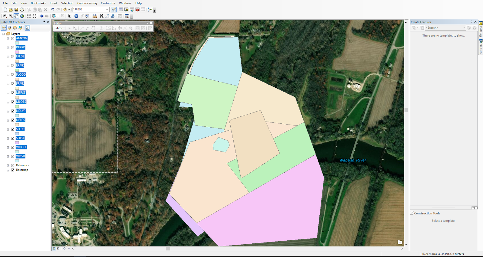 |
| Flight areas segmented out inside of large flight area above. The 5-letter identifiers (identified below) are highlighted on the left side with their corresponding color. |
AMPON -- Amphitheatre Only
SFRST -- South Forest
EFLDS -- East Fields
SFLDS -- South Fields
MLOTS -- Main Lots (Parking lots)
NFLDS -- North Fields
MFRST -- Main Forest
NDLVP -- North Developed
WHOLE -- Whole area
FLOOD -- Flood area
FRIVR -- Full River
ERIVR -- East River section
WRIVR -- West River Section
__________________________________________________________________________________
Map created using acquired dataset. Corresponds with write up in "ArcMap and ArcScene Map Creation".

_________________________________________________________________________________
INSPIRE PRACTICE CHECKLIST:
This checklist was created in conjunction with the activity performed in the "Inspire Practice" blog post
Checklist
DJI Inspire Checklist
- Ensure Pilot in Command is in good mental condition (sufficient sleep, more than 10 hours, and no mind-altering substances)
- Ensure battery percentage level ≥ 95%
- Ensure controller is charged ≥ 95%
- SD card inserted in and has sufficient space for data
- Ensure firmware is up to date and installed on aircraft
- Clean camera lens of any debris or obstruction
- Check image on viewing device for any obstructions or damage to camera, or blurriness
- Check airspace restrictions
- Check Wx
- Precipitation less than 5%
- Winds under 10 knots
- Ensure visibility is enough and legal
- Ensure flight is in between civil twilight hours (see local time for specific times)
- Ensure flight area is unobstructed and safe for flight
- Pre-flight check on airframe
- Camera locked in place
- Motors clear of FOD
- Check propellers for damage
- Ensure propellers are locked into place
- Ensure take off area is unobstructed
Red Edge Checklist
- Ensure RedEdge has SD card inserted in
- Connect GPS module
- Connect power cable
- Power on the camera with the On/Off button.
- The LED will remain off while the camera turns on
- Ensure camera is connected through Wi-Fi
- Make sure status information is as follows
- # of satellites used
- Altitude is set to 0 AGL
- Check the signal strength of each satellite
Post Flight Checklist
- Power off aircraft
- Power off Red Edge
- Remove SD card from payload
- Connect SD card to computer to ensure quality images
- If image quality is good: continue
- If image quality is poor, adjust accordingly and refly
- Power on drone and reconnect to controller
- Put drone into travel mode by flipping landing gear switch up and down 5 times
- Power down drone
- Remove battery
- Power down transmitter
- Remove props and place in case
- Disconnect and remove Red Edge sensor and place it in its appropriate housing
- Put drone and transmitter in their case and lock
________________________________________________________________________________________
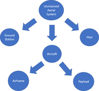
UAS DACUM:
UAS DACUM Model
Current and Future UAS Industry Trends
Trends
|
Explanation
|
Beyond
Visual Line of Sight (BVLOS)
|
Fixed wing
aircraft flying along rail lines. ~5-hour missions
|
Rail
inspection
|
Mapping
yards and switches
|
Pipeline
Inspection
|
|
Advanced
Ground Control GPS
Technology
|
New
technology that allows for faster collection of Ground Control Tie-Ins.
Aeropoints as an example
|
Autonomous
Delivery
|
(Concept):
Amazon delivering packages via UAS
|
Advanced
Methods and Technology in RTK Platform based GPS accuracy in data collection
|
|
Construction
|
Site
scans, progress reports, overview images
|
High
Resolution Remote Sensing
|
|
Airspace
Integration
|
Flying
in/near airports & Runway inspection
|
Swarm
Technology
|
Multiple
autonomous platforms working together to complete one goal.
|
Scientific
Research
|
|
Natural
Resource Management
|
Resource
inventory, change analysis, productivity and condition analysis.
|
Windmill
Inspection
|
Reducing
operation & maintenance costs
|
3D Mapping
|
|
Manned-Unmanned
Team (MUMT)
|
Drones
and manned aircraft utilizing same airspace or target area to collective
gather data or accomplish similar task.
|
Vegetation
Mapping
|
Monitoring
vegetation growth using hyperspectral NIR
|
Water
column mapping
|
Using
differences in reflected/refracted light received by a sensor to map vertical
columns of water based on depth.
|
Hazard
Risk Assessment (weather, geological, environmental, etc)
|
Fault line
mapping, water drainage mapping, flood plain mapping, slope stability
analysis, forest fire risk analysis
|
Real
Estate Marketing
|
Arial
images of various angles of the house/property, neighborhood images
|
All
weather operations
|
Weatherized
airframe
|
Site
Surveying
|
Matching
point clouds with CAD elevation maps
|
Site
progression
|
|
Energy
|
Used to
assess pipelines and energy networks
|
Endurance/extended
duration
|
|
Light
Shows /leisure /recreation
|
Companies
like Intel use drones for entertainment purposes
|
Accident
Reconstruction
|
Post-crash
scene scans, gather information to show police, juries, investigators, etc.
|
Search and
Rescue
|
Emergency
services searching vast areas for missing persons
|
RC Racing
|
Innovation
through commercial application utilizing the entertainment markets.
|
Firefighting
|
Assistance
in finding safe routes of use. Thermal
imaging and analysis.
|
Police
|
Documenting
crime scenes, surveying disaster sites, accident & traffic management
|
Emergency
(medical)
|
Delivery
of medical supplies (Zipline company)
|
Cinematography
|
Take a
video of it
|
Agriculture
|
Can
collect crop count and assess crop quality
|
Surveillance
|
Can be
used to monitor any high security area
|
Deep
learning flight controls and data processing
|
Unsupervised
data management and classification.
|
Full
Motion Video
|
Video
Taken in MISB format. Video has bounding Geospatial coordinates
|
Geospatial
Video
|
Video
connected to UAS log file so it has coordinates
|
Policy and
Regulation
|
More
structure to UAS Commercial Remote Pilot License Categories. Also relates to
certification of different classes of aircraft.
|
Increasing
Markets and Applications of Tethered UAS platforms
|
Tethered
power supply UAS platforms have the potential to serve for long term
surveillance and other services where
|
More
efficient Solar Panel Arrays
|
Increased
flight times can come from axillary solar panels that provide trickle charge
to the electric power source to the UAS
|
UAS Critical Skills and Knowledge
Skillset/Knowledge
|
UAS Course Applied to:
|
Project
Management
|
AT 203
|
Geospatial
Knowledge
|
AT 319
AT 309
|
Cartographic
Knowledge
|
NA
|
Post-Processing
of UAS data
|
AT 319
(Small component)
|
Integration
with GIS and RS software
|
NA
|
Quick-thinking/adaptability
|
Throughout
curriculum
|
Regulation
Knowledge
|
AT 144
AT 286
|
Repair and
Maintenance
|
AT 219
|
Flight
Proficiency
|
AT 219
AT 309
|
Sensor
Integration/Familiarity
|
AT 309
|
Remote
Sensing
|
AT 319
|
Quality
control of data
|
NA
|
Data
management/Computer Science
|
NA
|
Integration
with manned aircraft
|
AT 286
|
Potential/Future
Applications
|
AT 409
|
Technical
Writing
|
AT 409,
ENG 420
|
Programming
|
NA
|
Management
|
Entrepreneurship
Certificate
|
Marketing
|
|
Graphic
Communication
|
|
Ethics
|
AT 309 AT
319
|
Soldering
|
AT 219 AT
309 AT 319
|
Systems
Engineering
|
Lightly
throughout curriculum
|
Electronics
design
|
|
UAS Technician Key Duties
Mission Planning
|
Description
|
Airworthiness
Inspection
|
Ensuring
aircraft is in a safe condition to fly and in compliance to manufactures
guidelines.
|
Airframe
integrity inspection
|
Checking
critical parts of the aircraft for structural integrity. Search for
deficiencies that may limit flight characteristics
|
Find the
highest object in flight path
|
For
collision avoidance, ensures that your flight altitude will not hit any
obstacles
|
Gather
weather data
|
Weather
must be within the aircraft’s and your personal limitations
|
Airspace
analysis
|
Must get
permission in certain airspace
|
Data
capture and quality considerations
|
|
Sensor
selection
|
Choosing
the correct sensor for the mission at hand
|
Crew
selection
|
|
Geospatial Duties
|
|
Plan out
missions using various forms of geospatial data
|
|
Understanding
capabilities and limits of Sensors and UAS platforms
|
|
Being able
to apply the right sensor and platform to the job
|
|
Being able
to properly gather Ground Control Points with survey grade GPS
|
|
UAS Maintenance
|
|
Ensure
proper record keeping
|
Proper
record keeping of replaced and repaired parts. Proper record keeping of
flight time and incidents.
|
Standardization
of maintenance techniques (like AC 43.13)
|
|
Maintain
Scheduled Maintenance Plan/Logs
|
|
Software
Troubleshooting
|
|
Regular
inspection of flight critical parts
|
|
Knowledge
of UAS maintenance software and applications
|
|
Maintaining
Field Kit
|
|
Flight Operations
|
|
Maintain
Safe Conduct Throughout Flight
|
|
Crew
Management
|
|
Preflight
Operations
|
|
Post-flight
checklists
|
|
Proper
Debriefing
|
|
What
belongs in a UAS field kit
|
|
Repair
techniques and procedures
|
|
Data
Capture Considerations
|
|
Communication
|
|
Customer
interaction
|
|
Marketing
/Networking
|
|
Non-crew
teamwork
|
|
Crew
Resource Management
|
|
_________________
UAS DACUM Model +Edits
Individual additions highlighted and italicized
Current and Future UAS Industry Trends
Trends
|
Explanation
|
Beyond
Visual Line of Sight (BVLOS)
|
Fixed wing
aircraft flying along rail lines. ~5-hour missions
|
Rail
inspection
|
Mapping
yards and switches
|
Pipeline
Inspection
|
Flying a fixed wing along miles of pipeline, capturing photos to be examined later
|
Advanced
Ground Control GPS
Technology
|
New
technology that allows for faster collection of Ground Control Tie-Ins.
Aeropoints as an example
|
Autonomous
Delivery
|
(Concept):
Amazon delivering packages via UAS
|
Advanced
Methods and Technology in RTK Platform based GPS accuracy in data collection
|
|
Construction
|
Site
scans, progress reports, overview images
|
High
Resolution Remote Sensing
|
|
Airspace
Integration
|
Flying
in/near airports & Runway inspection
|
Swarm
Technology
|
Multiple
autonomous platforms working together to complete one goal.
|
Scientific
Research
|
|
Natural
Resource Management
|
Resource
inventory, change analysis, productivity and condition analysis.
|
Windmill
Inspection
|
Reducing
operation & maintenance costs
|
3D Mapping
|
|
Manned-Unmanned
Team (MUMT)
|
Drones
and manned aircraft utilizing same airspace or target area to collective
gather data or accomplish similar task.
|
Vegetation
Mapping
|
Monitoring
vegetation growth using hyperspectral NIR
|
Water
column mapping
|
Using
differences in reflected/refracted light received by a sensor to map vertical
columns of water based on depth.
|
Hazard
Risk Assessment (weather, geological, environmental, etc)
|
Fault line
mapping, water drainage mapping, flood plain mapping, slope stability
analysis, forest fire risk analysis
|
Real
Estate Marketing
|
Arial
images of various angles of the house/property, neighborhood images
|
All
weather operations
|
Weatherized
airframe
|
Site
Surveying
|
Matching
point clouds with CAD elevation maps
|
Site
progression
|
Used in construction, maps constructed daily, weekly, etc. to show the project manager how far along the project is from a top-down view
|
Energy
|
Used to
assess pipelines and energy networks
|
Endurance/extended
duration
|
Using alternative methods (i.e. solar charging during flight, etc.) to increase flight time
|
Light
Shows /leisure /recreation
|
Companies
like Intel use drones for entertainment purposes
|
Accident
Reconstruction
|
Post-crash
scene scans, gather information to show police, juries, investigators, etc.
|
Search and
Rescue
|
Emergency
services searching vast areas for missing persons
|
RC Racing
|
Innovation
through commercial application utilizing the entertainment markets.
|
Firefighting
|
Assistance
in finding safe routes of use. Thermal
imaging and analysis.
|
Police
|
Documenting
crime scenes, surveying disaster sites, accident & traffic management
|
Emergency
(medical)
|
Delivery
of medical supplies (Zipline company)
|
Cinematography
|
Take a
video of it
|
Agriculture
|
Can
collect crop count and assess crop quality
|
Surveillance
|
Can be
used to monitor any high security area
|
Deep
learning flight controls and data processing
|
Unsupervised
data management and classification.
|
Full
Motion Video
|
Video
Taken in MISB format. Video has bounding Geospatial coordinates
|
Geospatial
Video
|
Video
connected to UAS log file so it has coordinates
|
Policy and
Regulation
|
More
structure to UAS Commercial Remote Pilot License Categories. Also relates to
certification of different classes of aircraft.
|
Increasing
Markets and Applications of Tethered UAS platforms
|
Tethered
power supply UAS platforms have the potential to serve for long term
surveillance and other services where
|
More
efficient Solar Panel Arrays
|
Increased
flight times can come from axillary solar panels that provide trickle charge
to the electric power source to the UAS
|
UAS Critical Skills and Knowledge
Skillset/Knowledge
|
UAS Course Applied to:
|
Project
Management
|
AT 203
|
Geospatial
Knowledge
|
AT 319
AT 309
|
Cartographic
Knowledge
|
NA
|
Post-Processing
of UAS data
|
AT 319
(Small component)
|
Integration
with GIS and RS software
|
NA
|
Quick-thinking/adaptability
|
Throughout
curriculum
|
Regulation
Knowledge
|
AT 144
AT 286
|
Repair and
Maintenance
|
AT 219
|
Flight
Proficiency
|
AT 219
AT 309
|
Sensor
Integration/Familiarity
|
AT 309
|
Remote
Sensing
|
AT 319
|
Quality
control of data
|
NA
|
Data
management/Computer Science
|
NA
|
Integration
with manned aircraft
|
AT 286
|
Potential/Future
Applications
|
AT 409
|
Technical
Writing
|
AT 409,
ENG 420
|
Programming
|
NA
|
Management
|
Entrepreneurship
Certificate
|
Marketing
|
|
Graphic
Communication
|
|
Ethics
|
AT 309 AT
319
|
Soldering
|
AT 219 AT
309 AT 319
|
Systems
Engineering
|
Lightly
throughout curriculum
|
Electronics
design
|
|
UAS Technician Key Duties
Mission Planning
|
Description
|
Airworthiness
Inspection
|
Ensuring
aircraft is in a safe condition to fly and in compliance to manufactures
guidelines.
|
Airframe
integrity inspection
|
Checking
critical parts of the aircraft for structural integrity. Search for
deficiencies that may limit flight characteristics
|
Find the
highest object in flight path
|
For
collision avoidance, ensures that your flight altitude will not hit any
obstacles
|
Gather
weather data
|
Weather
must be within the aircraft’s and your personal limitations
|
Airspace
analysis
|
Must get
permission in certain airspace
|
Data
capture and quality considerations
|
|
Sensor
selection
|
Choosing
the correct sensor for the mission at hand
|
Crew
selection
|
Selecting appropriate crew members for different positions, some of which are included below. Important to pick the most qualified individuals for each task to ensure safety and efficiency.
|
Geospatial Duties
|
|
Plan out
missions using various forms of geospatial data
|
|
Understanding
capabilities and limits of Sensors and UAS platforms
|
|
Being able
to apply the right sensor and platform to the job
|
Identifying the needs of the project, then selecting the appropriate payload accordingly so as not to waste time/money
|
Being able
to properly gather Ground Control Points with survey grade GPS
|
|
UAS Maintenance
|
|
Ensure
proper record keeping
|
Proper
record keeping of replaced and repaired parts. Proper record keeping of
flight time and incidents.
|
Standardization
of maintenance techniques (like AC 43.13)
|
|
Maintain
Scheduled Maintenance Plan/Logs
|
|
Software
Troubleshooting
|
|
Regular
inspection of flight critical parts
|
Certified mechanic, or someone who is an expert with that aircraft should perform 50, 100, 150 hr, etc. inspections
|
Knowledge
of UAS maintenance software and applications
|
Adapt to constantly evolving UAS software
|
Maintaining
Field Kit
|
Have equipment in the field ready to go in the event that something goes wrong (i.e. prop breaks, screw is loose, etc.)
|
Flight Operations
|
|
Maintain
Safe Conduct Throughout Flight
|
No horseplay, eyes on aircraft, hands ready to alter inputs at any moment
|
Crew
Management
|
Ensure everyone in the operation is on the same page. Have as many eyes on the aircraft as possible, and make sure that everyone performs their task
|
Preflight
Operations
|
Checklists are necessary. No skipping steps.
|
Post-flight
checklists
|
Most aircraft are unable to go right back in the box post-flight. Make sure the operator knows the proper post-flight procedures and follows the manual
|
Proper
Debriefing
|
Post-flight debriefs allow the crew to discuss important aspects of the flight. Make sure somebody records important notes as these can be used to improve future operations
|
What
belongs in a UAS field kit
|
Varies mission by mission. Important things to have may include but are not limited to: Extra props/wings, allen wrenches, screwdrivers, extra nuts & bolts, battery chargers, etc.
|
Repair
techniques and procedures
|
Shall be performed by an aircraft expert.
|
Data
Capture Considerations
|
|
Communication
|
|
Customer
interaction
|
What does the customer want? What are their product needs? How much time do they have before they need the product? How can we best meet their expectations?
|
Marketing
/Networking
|
Getting your product/service out there to expand your network
|
Non-crew
teamwork
|
Non-team members oftentimes create distractions, ensure that they know the rules of the operations and include them in pre-flight briefing if possible
|
Crew
Resource Management
|
See flight operations --> Crew management
|

Comments
Post a Comment