Posts

Showing posts from January, 2019

Progress Report #3 (Updated w/ Week 4)

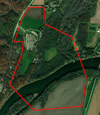
This week, after the completion of the flight area shape files, I finalized the weekly flight schedule. There is a good spread of people flying each day of the week, so once we are able to begin flying I will be able to assign who to out in the field each day. Tomorrow the weather is supposed to be dangerously cold, so much so that Purdue may cancel their classes. If this is the case, then we will push back our Wednesday plans to next week. However, if we do have class as scheduled we will have a "dry run", or a simulated situation. Evan, Thomas, and I will work together to create a situation such as recent flooding and let the class figure out what needs to be accomplished for the mission to be successful. This may include sensor integration, flight planning, designating takeoff and landing zones, etc. Hopefully we are able to complete that this week. Update:  Week four was a slow week because we decided to not require a meeting on Monday. We had planned to test out a dry-

Progress Report #2

Image
This week the team was faced with cold weather and heavy snowfall which caused us to remain inside and continue conducting lab work. This presented a great opportunity to create the shape files for the different flight areas around the park. To do this, I worked alongside the data manager Evan to work inside of the ArcMap software to draw out areas of interest. These areas were given a unique 5-letter identifier. After completing these segments, I went through and began making notes on each of the segments, beginning with what the 5-letter identifier stands for. I did this so that anyone who goes out into the field knows which areas I am talking about when I tell them where to fly. This week, I plan to add in other notes such as: takeoff/landing zones, aircraft to fly, and points of interest like tall trees or cable lines. These notes will most likely remain fluid throughout the semester as I will work with Evan to adjust how we capture data. Overhead outline of the entire flight

Progress Report #1

Our team has wrapped up our first week of classes and are now ready to begin moving forward with this capstone project. During the first week, we began laying the ground work for our flights, data storage, and mission planning. As operations manager, I have begun creating the flight schedule and flight plan files. Today in class, Evan and I worked with the ArcGIS software to create the mission files, these files will be brought into the mission planning software to ensure precise data collection in each of the specified areas. On Wednesday we plan to work with Thomas to complete this files and come up with five letter names for each of them. As I complete the flight schedule I am keeping a couple considerations in mind: I want to have teams of two or three out in the field together and scheduled flights every week as well as people ready to fly in the case of a sudden event (such as flooding). My goal is to have the flights take place at the same time of day so that we can have consi