Progress Report #2
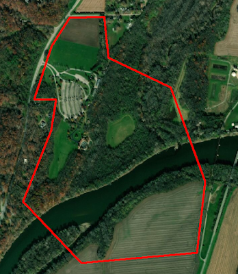
This week the team was faced with cold weather and heavy snowfall which caused us to remain inside and continue conducting lab work. This presented a great opportunity to create the shape files for the different flight areas around the park. To do this, I worked alongside the data manager Evan to work inside of the ArcMap software to draw out areas of interest. These areas were given a unique 5-letter identifier. After completing these segments, I went through and began making notes on each of the segments, beginning with what the 5-letter identifier stands for. I did this so that anyone who goes out into the field knows which areas I am talking about when I tell them where to fly. This week, I plan to add in other notes such as: takeoff/landing zones, aircraft to fly, and points of interest like tall trees or cable lines. These notes will most likely remain fluid throughout the semester as I will work with Evan to adjust how we capture data. Overhead outline of the entire flight...