Progress Report #2
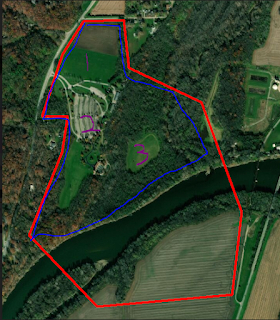
This week the team was faced with cold weather and heavy snowfall which caused us to remain inside and continue conducting lab work. This presented a great opportunity to create the shape files for the different flight areas around the park. To do this, I worked alongside the data manager Evan to work inside of the ArcMap software to draw out areas of interest. These areas were given a unique 5-letter identifier.
After completing these segments, I went through and began making notes on each of the segments, beginning with what the 5-letter identifier stands for. I did this so that anyone who goes out into the field knows which areas I am talking about when I tell them where to fly. This week, I plan to add in other notes such as: takeoff/landing zones, aircraft to fly, and points of interest like tall trees or cable lines. These notes will most likely remain fluid throughout the semester as I will work with Evan to adjust how we capture data.
The 5-letter identifiers are shown below:
DFPRK -- Davis Ferry Park
AMPON -- Amphitheatre Only
SFRST -- South Forest
EFLDS -- East Fields
SFLDS -- South Fields
MLOTS -- Main Lots (Parking lots)
NFLDS -- North Fields
MFRST -- Main Forest
NDLVP -- North Developed
WHOLE -- Whole area
FLOOD -- Flood area
FRIVR -- Full River
ERIVR -- East River section
WRIVR -- West River Section
I am currently finalizing the schedule and aim to have it done by the first flight mission. Once I have completed this, I will post the schedule to the "Figures" page. As everyone's schedule is changing at this point in the semester it is important for me to remain in communication with my teammates so that I do not schedule them in their busy time.
After completing these segments, I went through and began making notes on each of the segments, beginning with what the 5-letter identifier stands for. I did this so that anyone who goes out into the field knows which areas I am talking about when I tell them where to fly. This week, I plan to add in other notes such as: takeoff/landing zones, aircraft to fly, and points of interest like tall trees or cable lines. These notes will most likely remain fluid throughout the semester as I will work with Evan to adjust how we capture data.
 |
| Overhead outline of the entire flight area to be covered |
 |
| Flight areas segmented out inside of large flight area above. The 5-letter identifiers are highlighted on the left side with their corresponding color. |
The 5-letter identifiers are shown below:
DFPRK -- Davis Ferry Park
AMPON -- Amphitheatre Only
SFRST -- South Forest
EFLDS -- East Fields
SFLDS -- South Fields
MLOTS -- Main Lots (Parking lots)
NFLDS -- North Fields
MFRST -- Main Forest
NDLVP -- North Developed
WHOLE -- Whole area
FLOOD -- Flood area
FRIVR -- Full River
ERIVR -- East River section
WRIVR -- West River Section
I am currently finalizing the schedule and aim to have it done by the first flight mission. Once I have completed this, I will post the schedule to the "Figures" page. As everyone's schedule is changing at this point in the semester it is important for me to remain in communication with my teammates so that I do not schedule them in their busy time.

Comments
Post a Comment