This week's post highlights some of the comparisons between two applications that we are using Drone Logbook and Measure. Both of these apps are used as a ground control station link between your phone/tablet and the aircraft you are flying. In this post, I hope to highlight some of the key features of each app, and at the end I will offer some insight into my team's opinion on the apps.
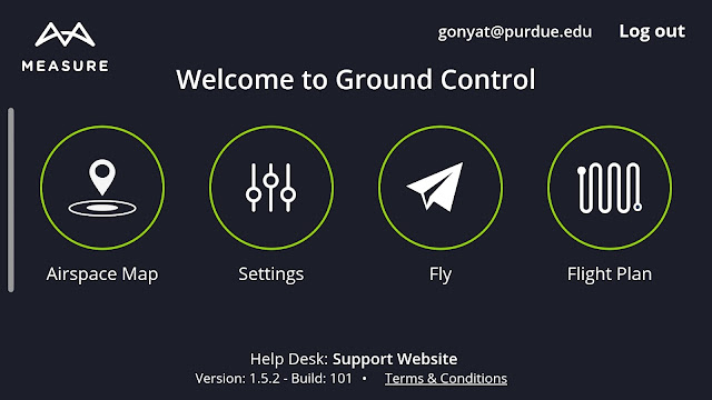
We begin by comparing the startup pages. First, the measure app has a clean startup screen where you are given four simple options: "airspace map" where you can view surrounding airspace and where you are legal to fly, "settings" where you can adjust in-app settings, "fly" which takes you to the flight deck allowing you to see through the lens of the UAV (if applicable) and view real-time flight data, and "flight plan" where you are able to draw out the polygon that you are wanting to fly and adjust the overlap, speed, etc. This startup screen is a very clean and effective setup and changed my opinion on this app. Originally my only experience with measure was their web application, where we were unable to perform many tasks. However, after my team went through this application we were thoroughly impressed.

Drone Logbook's startup screen is simply an overview of all of your menus combined. The "scan item bar-code" feature allows you to easily scan and add drones, equipment, and batteries to your inventory, allowing easy access and organization of a team or company's assets. Some of the other features such as "flying time" and "upcoming" are very nice features to have on the main screen. This information is important to know and constantly keep track of in case you need to back out of the flight screen or if the app happens to crash. None of these options are clickable on this main screen, but rather are sidebars on Drone Logbook's slide menu (Pictured below)
 |
| Drone Logbook's side menu |
Inside of each of the respective applications, we were able to capture screenshots of certain features which I will include below:
 |
| Drone Logbook's inventory system. In this scenario, it is showing all of the drone's under this fleet. This option is also available for maintenance logs/reports, batteries, flight locations, other equipment such as cameras or sensors, and incident reports. |
 |
| Measure's flight planning software allows you to easily draw a specific section of area you want to cover. On top of this, it includes important information such as: area covered, estimated flight duration, and the number of images needed. You can adjust the resolution, aircraft speed, and camera angle to capture the desired data sets. |
 |
| Measure's airspace page. Pictured here is the restricted Class D airspace surrounding KLAF. Each of the grid squares can be expanded to show the altitude allowed for flight in that certain area. The smaller circle inside of the airspace denotes the hobbyist field in Lafayette. |
 |
| Drone Logbook allows you to synchronize your accounts across multiple platforms, allowing for simple integration. |
In the early stages of our project, both applications show promise. For now however, I believe we will work with Drone Logbook because our inventory is already included in this application.


Comments
Post a Comment