Progress Report #5
This week, we put our mission planning to the test with a simulated "dry-run" or run through of a mission. The mission that we chose this week was a flood event of the Wabash river. As the operations manager, I created a simulated scenario to give to the class. I told them "The Wabash river experienced flooding due to the intense rain fall overnight, and we need to find the extent of the flooding." I did not share with them how we were going to capture the data.
Some things that we considered with each category:
The walk-through was very productive, as we tossed around multiple ideas on what we need to capture, how we were going to capture it, etc. With Dr. Hupy guiding us, we established that we did not need to capture a specific flooding event, rather we could use the A800 high resolution camera to capture imagery of our entire area. This payload will allow us to create a detailed model of the area, including any elevation change. From there we can throw the data into one of our many softwares and simulate a "flooding". After we changed the flight plan from flood sensing to general flight in fair weather, here is what we came up with:
________________________________________________________________________________
Dry Run 2/6/19
Objective: Initial Area
How: Pictures
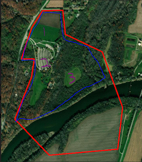
Shape file for mission: WHOLE
Platform: Bramor
Sensors: A800 high res
When is our mission: Monday 2/11/19
Who will be present: Thomas, Kyle, Todd, Dylan, Evan, Ian, Ryan, Hupy
Where are we taking off: NFLDS (north fields)
Where are we landing: NFLDS (north fields)
PIC: TODD
VO #: MIN 5
VO Placement: 2 davis ferry, 1 east field, 1 south field, 1 north field
________________________________________________________________________________
- We wanted to gather pictures with our high resolution camera and put them into photo stitching software
- The Bramor is a fixed wing aircraft with a long flight endurance. The flight area is over 800,000 sq. m
- Mondays are the best days to fly for us, as we have the most people available at varying times. Also this Monday specifically had good weather.
- NFLDS stands for north fields. By taking off in the northernmost area we can reduce the wasted flight time repeating areas.
- Todd is our designated Pilot in Command because he is our lead flight engineer
- We have a minimum of 5 visual observers, placed at the areas mentioned to ensure the aircraft is in constant view.
Although the weather will not allow us to fly this mission for a few weeks, it was beneficial to talk about it now so that when the time comes we will not be scrambling to get this baseline information figured out.

Comments
Post a Comment