Posts

Progress Report #8

Image
This week in class, our new aircraft the C-Astral Bramor. This is a catapult launched and parachute recover fixed wing aircraft. I only have a small range of fixed-wing UAV experience, so this is a great learning opportunity for me. During the first day of class, we all unboxed the aircraft and simulated a mission which involved: lab checklists, preflight construction, preflight checklists, and flight area mapping. As operations manager, I led the preflight operations (as pictured below). I led the team through the paper checklists provided by c-astral, however at certain points, parts of the checklists were confusing. Luckily, c-astral's ground control station includes a helpful expanded guide on checklists procedures giving us an extra sentence or two about things to do. Unfortunately, I did not capture pictures or screenshots of this. There were times however, when even the expanded checklists were confusing, and we had to seek the help of our professor. Demonstrat...
Progress Report #7

Image
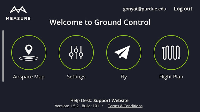
This week's post highlights some of the comparisons between two applications that we are using Drone Logbook and Measure. Both of these apps are used as a ground control station link between your phone/tablet and the aircraft you are flying. In this post, I hope to highlight some of the key features of each app, and at the end I will offer some insight into my team's opinion on the apps. We begin by comparing the startup pages. First, the measure app has a clean startup screen where you are given four simple options: "airspace map" where you can view surrounding airspace and where you are legal to fly, "settings" where you can adjust in-app settings, "fly" which takes you to the flight deck allowing you to see through the lens of the UAV (if applicable) and view real-time flight data, and "flight plan" where you are able to draw out the polygon that you are wanting to fly and adjust the overlap, speed, etc. This startup screen is a v...

Progress Report #6

Image
Every year, the School of Aviation and Transportation Technology holds a poster symposium which features student-led projects from the idea. As a capstone class, we aim to submit ~3-4 posters to this symposium to demonstrate some of the things that we have been working on in this capstone project. We want to demonstrate to people that UAS is much more than a "push button and fly" operation. We want to display the importance of things such as crew resource management, flight operations and implemented training, GPS, and applying geospatial data. So as a class, we brainstormed that those were the topics that we most wanted to cover. From there, we divided up into teams of two, the team names and focus areas are listed below: Team 1: Kyle and Thomas - operation management (structure of class) Team 2: Ian and Todd - Flight operation Training Team 3: Dylan and Ryan - GPS Team 4: Evan and Krysta - Applied Geospatial Data However, there may be some alterations to be ...

Progress Report #5

This week, we put our mission planning to the test with a simulated "dry-run" or run through of a mission. The mission that we chose this week was a flood event of the Wabash river. As the operations manager, I created a simulated scenario to give to the class. I told them "The Wabash river experienced flooding due to the intense rain fall overnight, and we need to find the extent of the flooding." I did not share with them how we were going to capture the data.  The walk-through was very productive, as we tossed around multiple ideas on what we need to capture, how we were going to capture it, etc. With Dr. Hupy guiding us, we established that we did not need to capture a specific flooding event, rather we could use the A800 high resolution camera to capture imagery of our entire area. This payload will allow us to create a detailed model of the area, including any elevation change. From there we can throw the data into one of our many softwares and simulate a ...

Progress Report #3 (Updated w/ Week 4)

This week, after the completion of the flight area shape files, I finalized the weekly flight schedule. There is a good spread of people flying each day of the week, so once we are able to begin flying I will be able to assign who to out in the field each day. Tomorrow the weather is supposed to be dangerously cold, so much so that Purdue may cancel their classes. If this is the case, then we will push back our Wednesday plans to next week. However, if we do have class as scheduled we will have a "dry run", or a simulated situation. Evan, Thomas, and I will work together to create a situation such as recent flooding and let the class figure out what needs to be accomplished for the mission to be successful. This may include sensor integration, flight planning, designating takeoff and landing zones, etc. Hopefully we are able to complete that this week. Update:  Week four was a slow week because we decided to not require a meeting on Monday. We had planned to test out a dry-...

Progress Report #2

Image
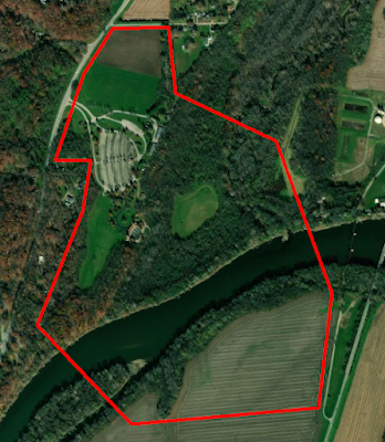
This week the team was faced with cold weather and heavy snowfall which caused us to remain inside and continue conducting lab work. This presented a great opportunity to create the shape files for the different flight areas around the park. To do this, I worked alongside the data manager Evan to work inside of the ArcMap software to draw out areas of interest. These areas were given a unique 5-letter identifier. After completing these segments, I went through and began making notes on each of the segments, beginning with what the 5-letter identifier stands for. I did this so that anyone who goes out into the field knows which areas I am talking about when I tell them where to fly. This week, I plan to add in other notes such as: takeoff/landing zones, aircraft to fly, and points of interest like tall trees or cable lines. These notes will most likely remain fluid throughout the semester as I will work with Evan to adjust how we capture data. Overhead outline of the entire flight...

Progress Report #1

Our team has wrapped up our first week of classes and are now ready to begin moving forward with this capstone project. During the first week, we began laying the ground work for our flights, data storage, and mission planning. As operations manager, I have begun creating the flight schedule and flight plan files. Today in class, Evan and I worked with the ArcGIS software to create the mission files, these files will be brought into the mission planning software to ensure precise data collection in each of the specified areas. On Wednesday we plan to work with Thomas to complete this files and come up with five letter names for each of them. As I complete the flight schedule I am keeping a couple considerations in mind: I want to have teams of two or three out in the field together and scheduled flights every week as well as people ready to fly in the case of a sudden event (such as flooding). My goal is to have the flights take place at the same time of day so that we can have consi...