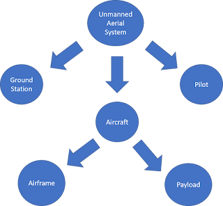
Consulting Report -- Train Inspection
There are over 76,000 railroad bridges spanning across the continental United States. These bridges cross over dangerous environments such as valleys, rivers, and large drop-offs. The current most accepted practice for inspecting bridges is to send a person down on a boom lift to inspect the underneath and sides of the bridge. However, this practice presents a great safety danger to the crew as equipment may defect and it oftentimes causes train delays/reroutes costing the company thousands of dollars. Using UAS for bridge inspections gets the person off the heavy machinery and on to solid ground where he/she can safely fly the aircraft capturing images at 20.8MP. Also, this allows trains to continue operations as the tracks do not get temporarily shut down.
The DJI Inspire 2 was chosen for this use due to its gimbal ability. The Inspire 2, designed for cinematography, can perform railroad bridge inspections as well. The Inspire 2 has great GPS accuracy, 0.33 feet with downward vision system enabled, for taking perfectly still accurate shots. Wind resisting flight of up to 10 m/s, helpful if there is a strong wind going under the bridge. With the long lasting 27-minute flight time, operators can maximize work done without the need of excess batteries or long charging sessions. The gimbal has a feature most of gimbals don’t and that is being able to pan upwards at a positive angle. The gimbal controllable range pitches from negative 130° to positive 40°, rolls from ±20°, and pans from ±320°.
The camera to be used is a ZENMUSE 4XS, this camera is used for its high resolution at a lower cost. The camera is easily detachable from the platform, in case of malfunctions or incidents. The camera has a 1-inch sensor with 20.8 mega-pixels to capture clear photos of any damage to the structure. This camera has an estimated 27 minutes of battery life instead of its predecessor the X5S which has an estimated battery life of 24 minutes. The camera can take videos in 4K at 60 frames per second. The camera can also take burst photos at 14 frames per second and take photos during video capture. The gimbal has incredible stability giving you a precise ±0.01°.
Bridge inspections require mobility and high detail imagery. This frame and camera are perfect for the job. The inspire 2 is able to precisely fly around the bridge and hover in place while correcting for wind gusts. The camera, capturing 20.8 megapixels allows the operator to capture imagery underneath the bridge while still flying away from the bridge to avoid interference or lost communication. With a +40◦ gimbal angle range, the DJI Inspire 2 is the perfect aircraft for capturing aerial imagery, as it can fly below bridge level and take pictures at a positive angle.
In high-crime rate areas such as Chicago, train car break-ins and vandalism are common problems train police forces must tackle. Currently, they cover the yards by driving around in their cars and walking around the lines shining flashlights looking for trespassers. The three main considerations when formulating a platform are: maneuverability, long flight endurance, and IR capabilities as these trespassing's occur at night. The DJI Phantom 4 pro quadcopter has a 30-minute battery life. This coupled with its integrated collision avoidance and swift maneuverability led to the choice of aircraft. The integrated payload is replaced with a FLIR VuePro Camera to allow the operator to track heat signatures through the yards.
The platform recommended for this mission is a Phantom 4 Pro. The Phantom 4 Pro has a wide variety of sensors available for use and can be equipped with various night vision/thermal sensors. The Phantom 4 Pro can fly for 30 minutes depending on payload. Its main camera shoots video in 4K at 60 frames per second. The camera can also take still photos with its 20-megapixel camera. Night time surveillance being the main use for this platform its camera would be useless but gives it versatility if needed to be used for daytime use.
The main use of this platform comes from its sensor, a FLIR VuePro. The FLIR VuePro is a thermal camera and data recorder. The VuePro’s spectral band is 7.5 - 13.5 µm with a zoomable function for closer views. Live feed video to main device lets user see real time footage. Easy to use phone app lets users select which color option they want to see their imaging in. Camera frame rate at 30 Hz for NTSC and 25 Hz for PAL. Sensor resolution is 640x512 giving the viewer a crisp thermal image. Putting together the sensor and airframe would give users a great platform to have an eye in the sky against potential criminals.
Night operations present a challenge for UAV operators, as they are unable to see any visual from the aircraft in flight. Equipping a thermal camera to the aircraft allows the operator to track heat signatures and gather a better understanding for the environment around them. By using a UAV, the police forces can cover an increased range, tagging specific vandal’s locations so that other officers may mobilize to the site and make the necessary arrests. The platform mentioned above is perfect for the operation. Its ability to maneuver easily and stay in the air for extended periods of time allow the police forces to work in high pressure areas with confidence.
Beyond visual line of site unmanned flight is becoming more accepted by the FAA. Although an exemption is required to fly past line of sight, the practice is very helpful for efficiently capturing data in certain fields. One of these fields is the rail industry, where thousands of miles require inspections. Historically there are different train cars strapped with cameras and sensors that ride along the tracks. However, with increased UAV technologies, overhead flights for rail inspection increases safety by getting people off the tracks.
Since this application demands a lot, the package isn't cheap. Roughly estimating 150,000 dollars the Latitude Aerosonde HQ offers a great deal of reliability. The Aerosonde is a VTOL UAS that can take off like a helicopter, fly like an airplane, then land like a helicopter. This is can be particularly useful for places where runway space is very limited. This is also useful because it eliminates the need for large systems to launch or recover the aircraft. Powered by a powerful, reliable Piccolo flight controller, the Aerosonde can fly for up to 14 hours. With this long duration, the Aerosonde has a range of 75 nautical miles. Giving users a long duration to capture data or perform missions. The Aerosonde can also carry up to 20 pounds also giving users the ability to use a wide range of sensors.
The camera chosen for this platform and mission is a TASE 400. This camera is a day and night camera. The camera is stabilized on 2 axis and is integrated with GPS. If users need to have data processed as soon as possible this camera also has onboard video processing. The TASE 400 is also environmentally sealed so that flying in rain or misty conditions won’t affect the camera. Weighing only 8 pounds it is well below the payload limit for the Aerosonde. 360-degree motion and live feed will give the operator live feed of anything that is around the Aerosonde While prices for these are not advertised, consumers can expect to pay a hefty amount.
Getting cars off the tracks also increases rail efficiency. Just like in the bridge inspections, by getting cars off the track they locomotives can continue typical operations without slowing down or rerouting. Using a fixed wing aircraft is necessary because of its long flight capability. Also, the aircraft must have vertical takeoff and landing (VTOL) capabilities because of the tight spaces along some parts of the rail lines where other launch and recovery tactics are not plausible.
(Created in association with Todd Horn)

Comments
Post a Comment